
Guides & videos
Exports — getting your data out and backing it up
In short: Forest Assist does not sync anything with any server. This module is the way out for your data — the only one.
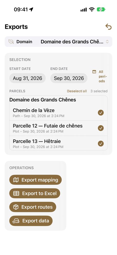
Four buttons, four different uses. The table below tells you which one to choose.
| You want to… | Use |
|---|---|
| view your parcels in a GIS (QGIS, Google Earth…) | Export mapping |
| hand a complete survey to someone else, readable as is | Export routes |
| work on your data in a spreadsheet | Export to Excel |
| protect yourself against losing your iPhone | Export data (full backup) |
Every export ends with the iPhone share sheet: AirDrop, Files, email, messaging… You choose the destination; the app knows of none.
First: the SELECTION section
At the top of the screen, you define the scope:
- the domain — the one shown in the banner;
- a date range (Start date / End date), both dates included. The All periods button widens it to all your observations on this domain;
- Parcels to tick, with Select all / Deselect all.
The Export mapping and Export to Excel buttons, stacked one above the other, stay greyed out as long as no parcel is ticked: that is the sign they work on your selection.
Export mapping (KML and GPX)
Produces one KML file per domain, with the selected parcels and paths.
KML opens in Google Earth, QGIS and most mapping software. Your parcels appear as polygons, your paths as lines. The GPS accuracy of each point is preserved.
Typical use: sending your boundaries to a surveyor or an expert, or overlaying them on the land register.
Your grids are exported with it (see Lay out a grid in a parcel):
- in the KML, each parcel with a grid has a folder named after it, such as Maillage — Plot A (maillage is French for grid), with one placemark per point (M01, M02…);
- a GPX file is added: each grid point becomes a waypoint in it ("Plot A M01"). This is the format read by field GPS units and hiking apps: you can reach your sample plots with a device other than the iPhone.
If no parcel in the selection has a grid, only the KML is produced.
Export to Excel
An .xlsx workbook with six sheets: Observations, Notes, Notes vocales (voice notes), Inventaires (inventories), Surface terrière (basal area) and Pédologie (pedology) — the sheet names are in French whatever the language of the app.
For each species, the workbook gives the international code, the genus, the Latin name and the common name in your language: your pivot tables and filters work straight away.
Typical use: calculating a volume, drawing up a stand table, preparing a management plan.
This output follows the selection: domain, dates and ticked parcels. The button only becomes active with at least one ticked parcel — like Export mapping, just above it. A domain that does not have any parcel yet therefore cannot be exported to Excel: first draw or record its parcel (see the Mapping guide).
Export routes
Designed to hand a complete survey to someone who does not have the app.
Choose a route from the list. The app produces a ZIP archive containing every item of the survey, numbered and time-stamped in the order you recorded them: photographs, voice notes, inventory sheets, basal area counts.
The recipient opens the archive and follows your route item by item, with no special tool.
Full backup — "Export data"
This is your safety net: a faithful copy of all your data, with or without your media.
- Tap Export data. The app calculates the sizes.
- The Backup type window offers three buttons directly, each showing its size:
| Button | The archive contains |
|---|---|
| Full | your data, your voice notes and your photographs and videos |
| Without photos | your data and your voice notes |
| Without audio | your data only |
- Tap the button of your choice: the archive is produced.
A button that would give exactly the same archive as the next one is not shown: with no photos at all, for example, Full does not appear; with neither photos nor voice notes, only one button remains.
The archive is saved on your iPhone, in Files, then offered for sharing.
Good to know
- One export at a time: the buttons are disabled while an archive is being prepared.
- Archives are not encrypted. They contain the precise locations of your properties, your contacts' details and your photographs: be careful who you send them to and where you store them.
- An export uses no credit, even with a zero balance.
- An export neither changes nor deletes anything: you can run it again as often as needed.
Our recommendation
| When | What |
|---|---|
| End of each field day | Full backup, sent off the phone |
| End of a job | Excel for analysis, KML for mapping, GPX to find your sample plots by GPS |
| Handing over to someone else | Export routes, or Excel |